ArcGIS Model Builder
ModelBuilder is an application in which you create, edit, and manage models. If you haven't done so already, you should read Creating a simple model, for it shows you, by example, the basic tasks of creating a model in ModelBuilder. You should also read An overview of model concepts and terms and the topics referenced there, since they define many of the terms used here.
The components of the ModelBuilder application are shown below.
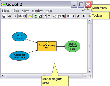
There are five pull-down menus on the Main menu.

The toolbar has the following buttons and tools:
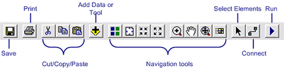
Read a synopsis of this toolbar
* The Add Data or Tool button is discussed in Creating model processes.
* Navigation tools are discussed in Navigating a model.
* Select Element allows you to select an element for moving, copying, accessing properties, and deleting.
* The Connect tool connects elements, such as a data variable to a tool, and is discussed in Creating model processes.
* The Run button runs the model and is discussed in Running a model.
You cannot customize this toolbar.
The topics that follow discuss the use of ModelBuilder and the mechanics of creating, editing, and managing models.
Model building approaches discusses the two basic approaches to model building.
When you build a model, you create processes (a process is a tool plus its data) and the connections between them, and Creating model processes shows you how.
You can run your models within ModelBuilder, or execute them like any other tool using the tool dialog or the Command Line window. Running a model shows you how to run models within ModelBuilder.
Validating a model shows you how to check your model for errors and to synchronize data variables.
Model environments discusses the use of geoprocessing environment variables and how they can be used in models.
Model appearance shows how you can change the look and arrangement of model elements to increase readability.
You can print a model diagram (Printing a model), generate and print a report (Model reporting), and export a model to a script (Exporting a model).
Model documentation is very important for sharing models. Documenting a process shows how to provide documentation for individual model processes.
-------- source information : http://webhelp.esri.com/arcgisdesktop/9.2/index.cfm?TopicName=An_overview_of_ModelBuilder
*******************************************************************
ArcGIS Model Builder :
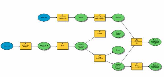
Terrain Analysis using Model Builder
Prepared by David R. Maidment and David G. Tarboton
Fall 2004
This tutorial shows how to solve a simple terrain processing and hydrologic analysis problem using the ArcGIS Model Builder to develop an automated workflow sequence. The input data are two small grids that can be typed in a word processor elev.txt and rain.txt. These grids contain a 6-line header file which defines the number of rows and columns, the coordinates of the lower left corner, the cellsize and the value for cells which have no real data in them. Then the data values follow in row-column format. All dimensions of the terrain grid are in meters and the rainfall is in mm.
========================================================================================
ArcGIS Model Builder
Local Examples of ArcGIS 9 Model Builder
VSDP Roundtable
13 July 2005
1. Montpelier Development Potential
Daniel Currier, Central Vermont Regional Planning Commission
http://www.centralvtplanning.com/
2. Natural Lands Trust Green Plan 2005
David Felcan, Avencia Incorporated
http://www.avencia.com/
3. Species Habitat Modeling
Ernest Buford, UVM Spatial Analysis Laboratory
http://www.uvm.edu/envnr/sal/
------------------------------------------------------------------------------------
ArcGIS Model Builder
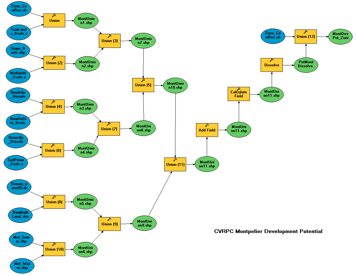
Montpelier Development Potential Model
CVRPC used this model to analyze development potential in the town
of Montpelier. The model basically performs many unions to overlay
eleven input layers that have all been scored according to their effect
on development potential.
-------------------------------------------------------------------------------------
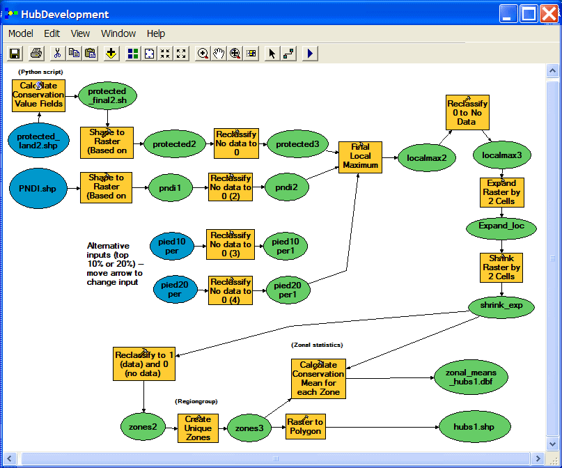
ArcGIS Model Builder
National Lands Trust Green Plan Model
The NTL Green Plan model combines several protected lands layers (polygon shapefiles)
into a single protected lands layer and performs an analysis that is used to identify
"hubs" of protected land that might serve as the core areas of a more well-connected
network of protected land.
-------------------------------------------------------------------------------------
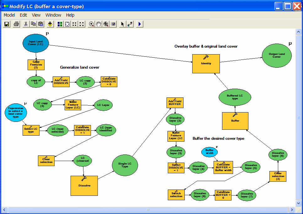
ArcGIS Model Builder
Species Distribution Modeling
One common way to create predicted distribution maps for animals is to
reclassify a land cover layer according to whether or not the species in
question would be predicted to use each cover type. These simple species
maps are often modified by using range data or such ancillary information as
elevation or distance to water. The Spatial Analysis Lab has done several
projects using this type of technique.
==============================================================================
ArcGIS Model Builder
bEST ReGards,
Aji Putra Perdana
- free gis'er -
Salam SPaSial dan NoN sPasiAL


