


Satelit SeaWIFS telah kembali beroperasi normal kembali dan ini sungguh kabar yang sangat menggembirakan bagi masyarakat penginderaan jauh pada umumnya dan terutama yang senang mengamati bumi :).
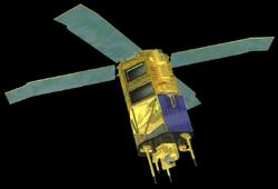
gambar di atas adalah satelit SeaWIFS
SeaWiFS stands for Sea-viewing Wide Field-of-view Sensor. It is the only scientific instrument on GeoEye's OrbView-2 (AKA SeaStar) satellite, and was a follow-on experiment to the Coastal Zone Color Scanner on Nimbus 7. Launched August 1, 1997 on an Orbital Sciences Pegasus small air-launched rocket, the instrument began scientific operations on 18 September 1997. The sensor resolution is 1.1 km (LAC), 4.5 km (GAC). The sensor records information in the following optical bands:
Band Wavelength
1 402-422 nm
2 433-453 nm
3 480-500 nm
4 500-520 nm
5 545-565 nm
6 660-680 nm
7 745-785 nm
8 845-885 nm
The instrument has been specifically designed to monitor ocean characteristics such as chlorophyll-a concentration and water clarity. The instrument is able to tilt up to 20 degrees to avoid sunlight from the sea surface. This feature is important at equatorial latitudes where glint from sunlight often obscures water colour.
sumber : http://en.wikipedia.org/wiki/SeaWiFS
Berikut sebuah tulisan dari situs oceancolor mengenai kembalinya SeaWIFS :
SeaWiFS Returns to Monitoring Our Home
We are so happy to report that after many months of hard work on the part of the folks at GeoEye, Orbital Sciences and NASA, SeaWiFS has been returned to normal operations as of yesterday, and, from what we have been able to tell so far from the imagery and telemetry, all systems are performing as they should and hopefully, this will be the resumption of a long and incredibly valuable data set. Thanks to everyone involved for their efforts on getting us back.
The above image shows Tropical Storm Fay and the eastern U.S. on August 20, 2008 while a more global perspective shows what other regions looked like on the same day.
untuk melihat-lihat gambar-gambar hasil rekaman satelit yang ada di situs oceancolor : Image Gallery


